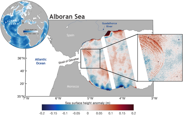
Gibraltar's internal wave viewed by Swot

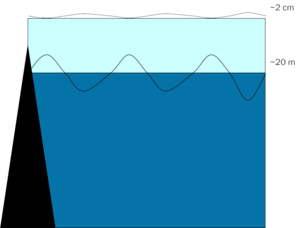
Internal waves are gravity waves propagating in the interior of a stratified fluid. They can also be seen on the surface of the fluid, albeit with a smaller amplitude. Straits are places where internal waves can often be observed as a series of concentric circles. These waves are caused by the flow of water (including tidal currents, in this case called internal tides) through the narrower passage, and their friction with the bathymetry - see a demonstration model in a tank. They play an important role in the mixing of ocean waters from the surface to the bottom, and in the redistribution of heat, nutrients, CO2, etc. They can also travel long distances (depending on the geography of the ocean basin), and thus transport heat and nutrients. We have already seen some of them as measured by Swot, probably generated on the bathymetry between Sumatra and the Andaman Islands)
They were quite difficult to detect with conventional altimeters, which only measure at nadir along the track, even though the signal can reach several centimeters in some locations. In straits, the very coastal environment also adds complexity to classical altimetry, while Swot, with its high spatial resolution, has no problem measuring up to the coasts.
Such waves have been observed in the past by satellites such as Sentinel-1 (Synthetic Aperture Radar), or optical satellites such as Sentinel-2, often in the closely monitored of Gibraltar Strait. The KaRIn instrument aboard Swot (Nasa/Cnes/CSA/UKSA) not only detects them in two dimensions in the Strait of Gibraltar, but also measures the height of internal waves generated on all the world's oceans, systematically at every cycle. This will make it possible to better understand and therefore model them. Several models have been developed in preparation for Swot, to try to correct the sea surface anomalies from internal tides for people who want to focus on meso- and submeso-scale circulation. These will now be compared with the actual measurements, and a second set of improved models will then be proposed to the users and the ground segment, as internal tide corrections.


