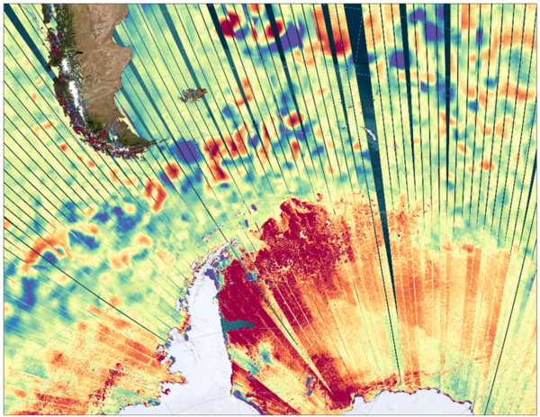
Swot scans the Southern Ocean
In this image, acquired at Cape Horn, between the tip of South America and the tip of Antarctica, during multiple passes of the Swot satellite, the differences in water surface height are clearly visible. These are represented by shades of blue for the lowest water and red for the highest. These differences are characteristic of ocean eddies, which Swot can observe from a few tens of kilometers away. This level of precision is unprecedented in oceanography, especially as it is accompanied by the ability to carry out measurements as close to the coast as possible.
What's more, the data presented on this map make it possible to clearly observe the boundary with the fractioned ice bordering the east coast of the Antarctic Peninsula. These data open up new perspectives in the use of Swot data for the study of sea ice, for example.
Thanks to the repeatability of its measurements, Swot will be able to regularly collect data in the most remote and least accessible regions of the globe, such as here in the southern zone.
Since July 2023, this Franco-American mission from Cnes and Nasa has been measuring the height of almost 90% of the water on the Earth's surface. Now in the calibration and validation phase, with over 60 in-situ measurement campaigns, the satellite is beginning to deliver its first scientific data, whose accuracy is already exceeding expectations.Once validated and made available to the public in the spring of 2024, this data should enable international scientists to better study the effects of climate change on the water cycle, or to better understand the mechanisms of carbon storage in the oceans.
More about the mission:
Launched from the US Space Force base at Vandenberg, California, USA, Swot is a collaborative mission between Cnes and Nasa, with contributions from the Canadian Space Agency (CSA) and the UK Space Agency (UKSA).
Swot's objective is to provide high-resolution measurements of water height in the world's oceans and surface freshwater bodies, with unrivalled accuracy. It will provide a better understanding of the ocean's role in climate change, and help local communities to monitor and plan for changes in water resources and the effects of rising sea levels.
As part of this international cooperation, Cnes is in charge of supplying the satellite's precise orbit with the Doris instrument, the Poseidon nadir altimeter and the radio-frequency subsystem at the heart of the KaRIn instrument. It is also supplying the satellite platform developed by Thales Alenia Space, as well as the ground control segment, and will process Swot data as it is received. Nasa is supplying the KaRIn instrument (integrating the radio-frequency subsystem supplied by Cnes and elements supplied by CSA and UKSA), a GPS receiver, a laser retroreflector and a dual-beam microwave radiometer. Finally, it supplied the satellite launch system from California and is in charge of global data reprocessing campaigns for the KaRIn instrument.
To find out more about the mission, visit the Cnes project page.


