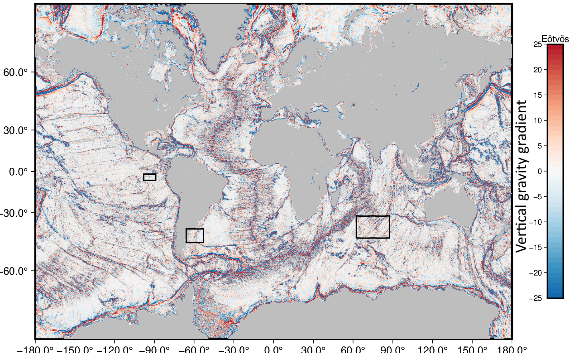
Global view of seafloor gravity and bathymetry from one year of Swot
")
")
")
No more than a quarter of the seafloor has been mapped by ships over all the oceans. Before, to fill in the gaps, marine gravity from satellite altimetry was used. However, it provides only low-resolution maps, and has problems with features such as abyssal hills, small seamounts, and continental margin structure.
Swot is dramatically improving the accuracy and resolution of sea surface height measurements, thus enabling to better map these small-scale undersea structures. A team from Scripps Institution of Oceanography has processed 1 year of Swot KaRIn ocean level-2 data (using both calval and science orbit) to extract the, which is the curvature of the ocean surface. As mentioned in Image of the Month, May 2024: Swot measurements help in seafloor mapping, a small bump in the ocean surface can be produced by a local increase in the pull of gravity due to extra mass. This enables to retrieve bathymetric highs associated with, for example, ridges or seamounts, which have an extra mass relative to the surrounding seafloor.
The use of another year or more of Swot science orbit data will further reduce the noise in the global vertical gravity gradient maps, and thus improve even more the resolution of seamounts, abyssal hills, and continental margins. This marine gravity will also be combined with available depth soundings, using machine learning methods, to dramatically improve global bathymetry, especially in the remote oceans.
This much better knowledge of bathymetry will support improved resolution models of ocean dynamics, including internal tides, as deep tidal currents flowing over rough abyssal hill produce internal waves, especially along rough slow spreading ridges.
Reference:
- Yu, Y. , D. T. Sandwell, G. Dibarboure, 2024: Abyssal marine tectonics from the SWOT mission.Science386,1251-1256(2024). DOI:10.1126/science.ads4472
The Surface Water and Ocean Topography (Swot) satellite-mounted instrument package is revolutionizing several areas of oceanography. An article by Scripps Institution of Oceanography at UC San Diego researchers Yao Yu and David Sandwell with colleague Gerald Dibarboure reveal sharper images of the seafloor made from only one year's worth of data collected from Swot. (Credit Scripps Institution of Oceanography)

