Swot's detailed view of the ocean

One of the Swot mission (Nasa/Cnes) goals is to detect fine scale ocean features (15-150 km), unprecedently observed with classical along-track measurements carried out by nadir-looking altimeters. These small features (e.g., sub-mesoscale to mesoscale eddies) are essential to better understand ocean dynamics and its variability, notably the way surface and deeper waters mix together. which has a huge impact on nutrient availability and marine ecosystems. Small scale ocean features are involved in the vertical and horizontal distributions of both nutrients and heat in the ocean, and also on ocean CO2 uptake (~30% of anthropogenic CO2 is taken up by the oceans).
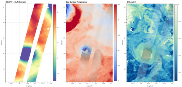
The left panel in the figure above shows the Swot Sea Surface Height Anomalies over the North-West Atlantic region on February 4, 2023. The width of each swath represents 50 km, thus giving an idea of the size of the details within (NB. Swot data shown are the baseline ocean data with a resolution of 2 km).
As a comparison, Sea Surface Temperature (middle panel) and Chlorophyll-A (right panel) maps over the same region are also shown in the figure above. They exhibit consistent spatial features (despite few data gaps due to cloudy conditions) with those mapped by Swot nadir and KaRIn instruments.


