Validating TOPEX/POSEIDON Significant Wave Heights
S. Barstow (OCEANOR, Norway)
The TOPEX/POSEIDON Ku-band altimeter measurements of significant wave height (Hm0) have recently been validated using an extensive set of in-situ buoy measurements.
The present study was initiated in connection with inclusion of TOPEX/POSEIDON data in the World Wave Atlas (accompanying article) and also to ensure bias free altimeter significant wave heights in a validation of a hindcast of the ECMWF'S WAM model being carried out in the EU Joule WERATLAS (European Wave Energy Resource Atlas) project in which OCEANOR is one of the partners.
The reference data comprise : n buoy measurements from Haltenbanken in the Norwegian Sea and an offshore site south of the Fiji Islands in the South Pacific (OCEANOR data), n data from 6 of the long term offshore NOAA National Data Buoy Center measurement stations off the west and east coasts of the USA, the Gulf of Mexico and Hawaii.
Data from the satellite and buoys were matched in space and time. The merged matched significant wave height and wind speed scatter plots for all validation locations are shown in the figure 1.
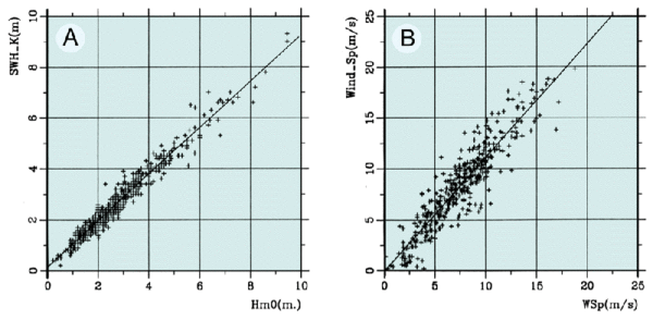
For significant wave height it was found that correction of the small systematic altimeter underestimate, given by the best fit regression line
Hm0T/P = 0.91 Hm0buoy (+/- 0.01) + 0.15 (+/- 0.03) (N = 524)
would allow accurate significant wave height statistics to be provided worldwide. Similarly, for wind speed, the altimeter overestimates by 10% compared to buoy 10 m winds with a standard deviation about the regression of 1.6 m/s as follows:
WspT/P = 1.10 Wspbuoy (+/- 0.01) (N = 378)
These results are consistent with an intercomparison recently published by Gower (1995) where TOPEX/POSEIDON data were compared with Canadian offshore buoys.
References
- Gower J.F.R., Proceedings of the 3rd Thematic Conference on Remote Sensing for Marine and Coastal Environments. Seattle, USA, Vol I, 95-103 (1995).

