Series of hurricanes
Image of the month - April 2005
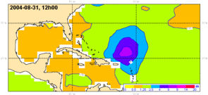
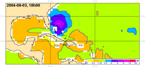
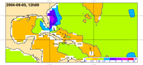
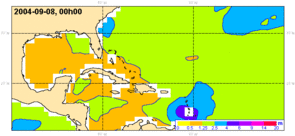
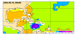
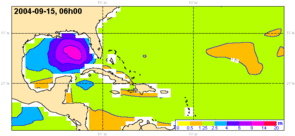
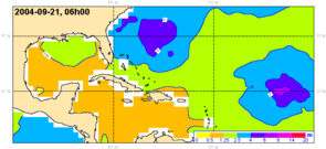
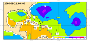
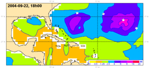
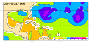
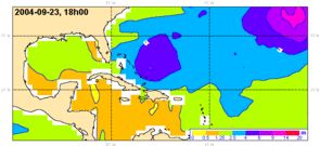
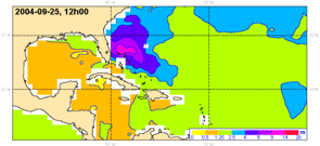
Significant wave heights from Météo France wave model with Jason-1 and ERS-2 data assimilation over September 2004 hurricane series in the Caribbean and Gulf of Mexico region, with Frances (25 Aug -8 Sep), Ivan (2-26 Sep) and Jeanne (13-28 Sep). Assimilation of altimetric data improves the forecasts. (Credits Météo France)
End of Summer and beginning of Fall are hurricane season in the Atlantic, when water reaches or exceeds 26°C over the first 60 meters (which are the conditions for a storm to become a hurricane). In 2004, a very high number of hurricanes struck the area with appalling human and economic consequences. On September 15, a buoy measured a significant wave height of 16 m (some waves went over 25 m) in the Gulf of Mexico under Ivan path. That is the highest wave height measured in the area during a hurricane (which doesn't mean even higher waves did not occur during this hurricane where there was no buoy to measure them). Sea state forecast during such events are a test for the models -- and an important information for seafarers.
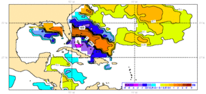
Altimetry can play a part in such event warnings, with its information about sea surface height (see Image of the Month, June 2004, Nida: altimetric view of a typhoon), but also with significant wave height measurements. Once assimilated in sea state forecast models, wave heights from altimetric satellites improve significantly their predictions. With data from two satellites, Jason-1 (Cnes/Nasa) and Envisat (Esa) assimilated, they are even more accurate.
See also:
- OST/ST 2004 meeting poster: Operational assimilation of altimeter wind/wave data, JM. Lefèvre et al. (pdf, 1,5 Mo)
- Applications: Marine meteorology and atmospheric studies
Websites on this subject:
- National Hurricane Center (Noaa)

