Floats everywhere
Image of the month - March 2005
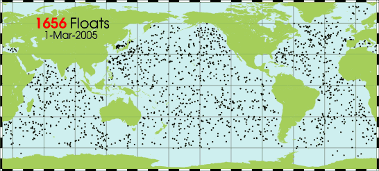
The Argo project has more than 1600 active profiling floats, provided by 18 nations -- France among them in the Coriolis project frame --, spanning the globe in the ice-free oceans. The goal is to have 3000 of them by 2006.
These floats dive at a depth of 2000 m, recording temperature and salinity along the way, and velocities at 1000 m. They surface every ten days to upload their data via satellites. Thus every month these instruments provide high quality data that are strongly complementary to satellite altimetric height, since they are giving information in depth. Comparisons are then possible, and that brings knowledge about where in the whole water column things are occuring.
With such a in situ data source as Argo, and altimetric satellites, ocean forecasts can reach an unprecedented accuracy.
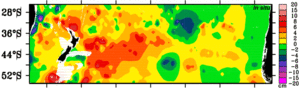
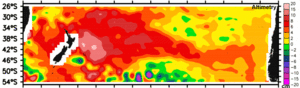
Dynamic height differences between two in situ measurement series, Woce and Argo, at a 10-year interval, top, and altimetric sea surface height difference over the same interval, bottom. The in situ data show that the 10-cm increase is due to temperature increase at depths from the sea surface to more than 2000 m. The pattern of temperature increase indicates an acceleration of the deep subtropical gyre circulation. (Credits Scripps Institution of Oceanography)
See also:
- OST/ST 2004 meeting poster: Argo and Jason in the South Pacific: Interannual-to-decadal variability in water mass properties and circulation, D. Roemmich and J. Gilson (pdf, 4 Mb)
- Image of the Month, June 2003: Combining sensors

