Satellites shed light on the Kon Tiki story
Image of the month - August 2005

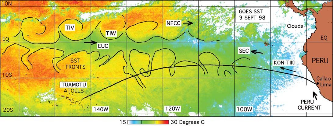
In April 1947, Thor Heyerdhal crossed the Pacific on a balsa raft called the Kon Tiki, to prove that it would have been possible for South America and Polynesia to have made contact a long time ago. While altimetric satellites (or any others for that matter) didn't exist at the time, it is possible to use them today to get a better understanding of the journey taken by the Kon Tiki.
The crossing was relatively fast: barely 3 months to cover the 7,700 km that separate Peru from the Tuamotu Islands. Heyerdhal noted that the raft was never driven back towards South America, and that the average speed was 42.5 nautical miles per day (about 75 km/day), with the help of the Trade Winds. Therefore, if 1947 (like 1948) had been an El Niño year, the Kon Tiki would probably not have completed the crossing as the winds would have been too weak or might even have blown the other way.
During its crossing the raft was deflected towards the South on several occasions. Onboard measurements revealed colder waters. Looking at this zone from satellites, we see the quasi-systematic presence of turbulence brought about by the meeting of a strip of cold water at the equator with the South-equatorial current, which creates cold currents towards the South (South of the equator). These Tropical Instability Waves are probably what the Kon Tiki crew recorded.
Altimetry in conjunction with other oceanographic measurements has advanced our knowledge of the ocean over the past 15 years. We know a lot more about currents now than in 1947, and today we can predict how they might change. Models of currents, El Niño etc. have been developed by drawing on this knowledge, and now enable navigators to choose their routes and the most suitable times for their sea crossings.
See also:
- Applications: Ocean large-scale circulation
Websites on this subject:
References
- Legeckis R., C.W. Brown, F. Bonjean and E.S. Johnson, 2004. Satellites reveal the influence of equatorial currents and tropical instability waves on the drift of the Kon-Tiki in the Pacific, Oceanography I, Vol.17, No.4, Dec. 2004.
- Legeckis, Richard; Brown, Christopher W.; Bonjean, Fabrice; Johnson, Eric S., 2004. The influence of tropical instability waves on phytoplankton blooms in the wake of the Marquesas Islands during 1998 and on the currents observed during the drift of the Kon-Tiki in 1947, Geophys. Res. Lett., Vol. 31, No. 23, L2330710.1029/2004GL021637

