Tsunami debris on the Pacific
Image of the Month - January 2012
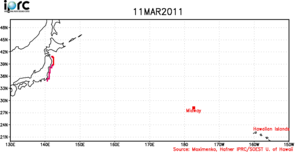
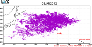
Debris dispersion on March 11, 2011 and January 8, 2012. The animation (GIF, 7,54 MB, AVI 432 KB) modelize the tracks of nearly 700 000 virtual tracers, initially distributed along the NE coast of Japan and weighted relative to the population (plot dated 11 March 2011). Then the tracers are carried by modelled currents and their location is plotted for each day. (Credits Nikolai Maximenko and Jan Hafner, IPRC/SOEST, University of Hawaii)
A tsunami hit Japan on March 11, 2011. When the water receded, it carried with it huge amounts of debris of any kind -- including houses and cars. Now, some of those debris are floatting in the Pacific, drifting with the winds and currents. Ocean models can be used to forecast the path of those depending on the ocean currents. Assimilation of altimetry data in ocean forecasting models enables to forecast day-to-day drifts, and thus to monitor where the most waste are expected to be at any given time. On the long term, the knowledge of currents in the area enable to build models that forecast that the majority of heavy debris will move towards the North Pacific Garbage Patch, a convergence located between Hawaii and California where floating objects tend to concentrate. There it will stay until changes in the winds and currents will eject it and send that which is still floating on towards Hawaii's east-facing shores.
Marine debris has become a serious problem for marine ecosystems, fisheries, and shipping. A better monitoring and forecast of those is becoming vital, especially after major events like this tsunami.
See also:
- Applications: Ocean large-scale circulation
- Applications: Operational oceanography
- Image of the Month, February 2011: Where does all the waste go?
Websites on this subject:
Reference:
- Nikolai Maximenko, Modeling distribution of marine debris before and after tsunami of March 11, 2011, OSTST meeting, San Diego, October 2011

