Following Kuroshio changing path
Image of the Month - March 2012
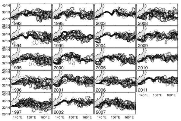
Yearly paths of the Kuroshio and Kuroshio Extension (paths are plotted every 14 days). 1993-1994, 2002-2004 and 2010-2011 are "stable" years (paths are closer to each others, their lengths is shorter), while 1996-2001 and 2006-2008 show high unstability. The measurements of the length of the paths provides with an indicator of this stability. (Credits University of Hawaii at Manoa)
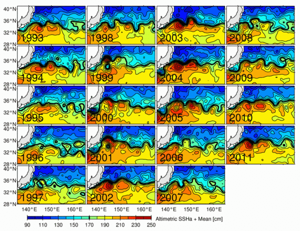
Kuroshio ("black current" in japanese) and its extension is one of the major currents in the Earth's oceans. Its path can vacillate between a dynamically stable and unstable state on the decadal timescales. As indicated in Jan. 2005 (see Image of the Month "Current heat"), the place and path of the Kuroshio (as well as the Gulf Stream) has an impact on climate, by modifying the heat content of the upper layers of the ocean, and the ocean-atmosphere exchanges. Thus understanding, monitoring (through indicators, in particular) and forecasting this is important for e.g. seasonal predictions.
With 20 years of continuous data, altimetry enable to catch year-to-year variation in the path of a current, and to better understand its mechanisms. The length of the path, its variability give an indication of the situation on a given year, which can be translated in figures, i.e. "indicators" or "indexes".
See also:
- Applications: Ocean large-scale circulation
- Applications: Climate
Websites on this subject:
- Ocean circulation (Espere project)
- Study of place - Ocean Currents Exploration (educational website)
References
- Qiu, B., and S. Chen, 2010: Eddy-mean flow interaction in the decadally-modulating Kuroshio Extension system. Deep-Sea Res. II, 57, 1098-1110.
- Qiu, B., and S. Chen, 2005: Variability of the Kuroshio Extension jet, recirculation gyre and mesoscale eddies on decadal timescales. J. Phys. Oceanogr., 35, 2090-2103.

