Arctic trends
Image of the Month - November 2012
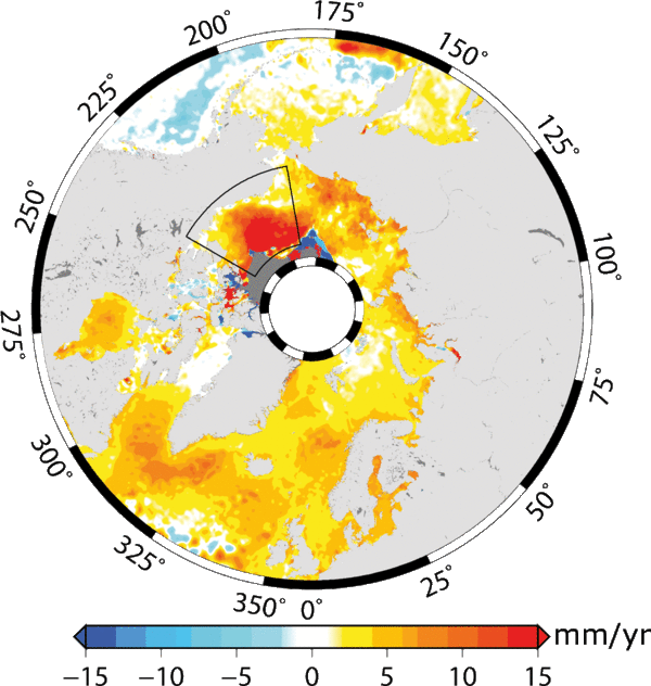
The Arctic ocean is one of the most sentisitive region with respect to climate variations. However, altimetry sea surface heights were not usually processed in this ocean, while satellites like ERS-1 & 2, or Envisat have measured up to 82°N all along the last 20 years or so, and while large portion of this ocean are ice-free at least part of the year. A dedicated processing was done, and made available to altimetry users this year. It shows a number of interesting features.
The Beaufort Sea, North of Canada, is a region where water accumulates, due to winds pushing water in the anticyclonic gyre there. Thus the sea level is usually higher in this region than average. During the last few years, the sea level was even higher there than usual, with a positive anomaly of the atmospheric circulation, and fresh water inputs (measured by in situ measurements).
With a satellite like Cryosat (measuring up to 88°), or the new missions that will be launched on Envisat tracks in the next years (Saral, Sentinel-3), the monitoring will continue.
See also:
- Data: Ssalto/Duacs near-real and delayed time multimission altimeter products - Arctic SLA
- Applications: Mean Sea Level
- Ocean indicators: Global Mean Sea Level
References
- Pierre Prandi, Michael Ablain, Anny Cazenave, Nicolas Picot, 2012, A new estimation of mean sea level in the Arctic Ocean from satellite altimetry, Marine Geodesy (in press)

