Antarctica thinning seen by Envisat
Image of the Month - June 2012

Antarctica is the biggest fresh water reservoir on Earth, storing about 70% of it. It also plays an active role in the climate due to the strong feedback induced by its high albedo, and can significantly contribute to sea level rise by its melting.
Antarctica is completely iced, but not still: glaciers are flowing all over the continent. Moreover, those glaciers react differently depending on the geographical area.
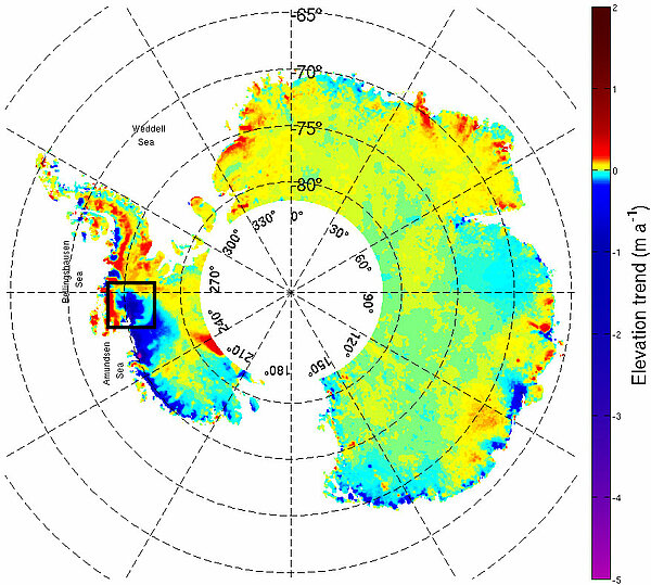
Between September 2002 and October 2010, Envisat radar altimeter measured the elevation of the Antarctic ice sheet along a repetitive track. Each ground track was observed about 85 times during this time. This long and regular time series is processed using an along-track algorithm to depict in detail the spatial and temporal pattern of elevation change for the whole ice sheet. One advantage of the finer along-track spacing of measurements is that it reveals places of dynamic thinning in regions of rapid ice flow. In West Antarctica, in the "Pacific" part, thos processing show that glaciers are thinning, losing up to several meters a year. Those that are reaching the Admunsen Sea even undergo an acceleration in their thinning which is measurable by altimetry. In East Antarctica, some glaciers are losing thickness, but without any observable acceleration.
Now that the Envisat mission has ended, other missions can measure up the poles: Cryosat, dedicated to these applications, and soon Saral, that will take over the Envisat's tracks.
See also:
- Applications: Ice sheets
- Image of the Month, April 2000: Rivers of ice in Antarctica
- Image of the Month, August 2000: A lake capped by ice
- Image of the Month, October 2010: Envisat measures up Antarctica
- Data: Geophysical Data Records
References:
- Flament, T. and F. Rémy (2012): Dynamic thinning of Antarctic glaciers from along-track repeat radar altimetry, Journal of Glaciology (accepted)

