Range latitudinal empirical correction for Jason-1/2/3 GDR
Type of dataset: auxiliary product
DOI: 10.24400/527896/a01-2024.008 - more metadata
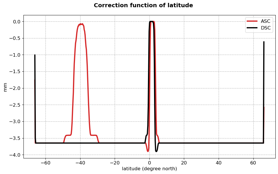
Contents: This dataset provides an abacus to correct from the effect of a rounding error in the ground processing of the Jason-1, Jason-2 and Jason-3 missions on the altimeter range estimations.
Use: geodesy, geophysics, oceanography (operational oceanography, modeling, ocean variability studies)
Description: The product named “Range latitudinal empirical correction for Jason-1/2/3 GDR” aims at providing an empirical correction for the Jason missions awaiting the exact correction in the ground segments. This abacus was produced by CLS as part of the CNES SALP project, distributed by AVISO+ with the support of CNES. It has to be applied on the GDR measurements for these 3 missions. This correction applies to GDR products in version F and previous. Note that this abacus is only valid for the Jason missions flying over the reference orbit. It cannot be applied over period where the satellites fly on other obits.
Format: netCDF-4 format
Condition of access: products delivered as stated in the licence agreement. This correction has to be applied to the GDR product so the access is the same: please fill in, select the product "Geophysical Data Records" or "Waveform (Radar return echoes in Sensor Geophysical Data Records)" or "Wind / Wave Along-track from Geophysical Data Records (L2)" and valid the registration form.
Distribution media: FTP/SFTP, Thredds Data Server (TDS); please refer to MY AVISO+
Citation: This product "Range latitudinal empirical correction for Jason-1/2/3 GDR" was produced by CLS as part of the CNES SALP project, distributed by AVISO+ with the support of CNES, (Version 1) [Data set]. CNES. doi.org/10.24400/527896/a01-2024.008
Tools and references:
- Range_Latitudinal_Empirical_Correction_For_Jason-1/2/3_GDR User Handbook
- Cadier et al., OSTST 2024, Comparison of Jason-3 and Sentinel-6MF observations in the equatorial band: was Topex right from the start?
Copyright: 1993-ongoing CNES-CLS
Range latitudinal empirical correction for Jason-1/2/3 GDR
| Product | Authenticated access service | type | format | File weight |
|---|---|---|---|---|
| Range latitudinal empirical correction for Jason-1/2/3 GDR | access via MY AVISO+ and select one of the products "Geophysical Data Records", "Waveform (Radar return echoes in Sensor Geophysical Data Records)" or "Wind / Wave Along-track from Geophysical Data Records (L2)" | correction versus latitude | NetCDF4 | 23.4 KB |

