Global Tide - FES2014 description
FES2014 is the last version of the FES (Finite Element Solution) tide model developed in 2014-2016. It is an improved version of the FES2012 model. This new FES2014 model has been developed, implemented and validated by the LEGOS, NOVELTIS and CLS, within a CNES funded project.
FES2014 takes advantage of longer altimeter time series and better altimeter standards, improved modeling and data assimilation techniques, a more accurate ocean bathymetry and a refined mesh in most of shallow water regions. Special efforts have been dedicated to address the major non-linear tides issue and to the determination of accurate tidal currents.
FES2014 is based on the resolution of the tidal barotropic equations (T-UGO model) in a spectral configuration.
A new global finite element grid (~2.9 million nodes, 50% more than FES2012) is used and model physic has been improved, leading to a nearly twice more accurate 'free' solution (independent of in situ and remote-sensing data) than the previous FES2012 version. Then the accuracy of this 'free' solution was improved by assimilating long-term altimetry data (Topex/ Poseidon, Jason-1, Jason-2, TPN-J1N, and ERS-1, ERS-2, ENVISAT) and tidal gauges through an improved representer assimilation method.
A preliminary version, noted FES2014a, has been produced in 2015 based on GOT4v8ac loading tide. Then new tide loading effects have been computed using FES2014a oceanic tide (J.P. Boy, Univ. Strasbourg). These FES2014a tide loading effects have been used to produce the final model version noted FES2014b:
FES2014b geocentric (elastic) tide = FES2014b oceanic tide + FES2014a loading tide.
Final FES2014b solution shows strong improvement compared to FES2012 and GOT4V10, particularly in coastal and shelf regions and also in some deep ocean areas and in the Arctic region.
The tide elevations, the tide currents and the tide loading grids are available for download. 34 tidal constituents are distributed on 1/16° grids (amplitude and phase) for each tidal product: 2N2,EPS2,J1,K1,K2,L2,La2,M2,M3,M4,M6,M8,Mf,MKS2,Mm,MN4,MS4,MSf,MSqm,Mtm,Mu2,N2,N4,Nu2,O1,P1,Q1,R2,S1,S2,S4,Sa,Ssa,T2.
A new prediction algorithm is distributed within the FES2014 package to provide tidal heights and currents at any location of the world ocean. This new prediction code allows computing 11 complementary HF constituents by the means of a specific admittance method and about 100 long period equilibrium ocean waves.
Validation versus tide gauge and altimetry
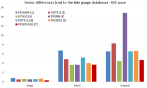
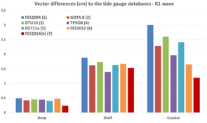
Complex differences with tide gauges for M2 (left) and K1 wave (right). This shows an improvement of FES2014b compared to other global tidal models in deep ocean and coastal and shelf areas. Credits LEGOS/Noveltis/CNES/CLS.
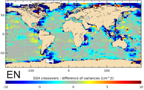
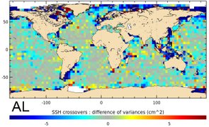
Variance reduction at crossovers for Jason-1 (left) and Envisat (right) when using the new FES2014 tide solution compared to FES2012. Credits LEGOS/Noveltis/CNES/CLS.

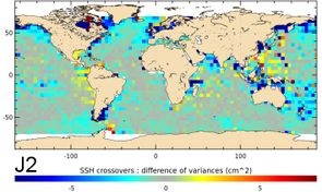
Variance reduction at crossovers for Jason-2 (left) and AltiKa (right) when using the new FES2014b tidal solution instead of GOT4V10. Credits LEGOS/Noveltis/CNES/CLS.
Main improvements between FES2014b and FES2012
- refinement of the finite element mesh (~2.9 million nodes = 50% more than FES2012)
- new global bathymetry including most recent global and regional datasets and specific filtering in some regions
- improved coastlines in coastal regions
- optimized assimilation scheme
- improved physic, particularly for the Hudson Bay region simulation
- assimilation of long time series of altimetric data with improved altimeter standards (Topex/Poseidon, Jason-1, Jason-2, TPN-J1N, ERS-1, ERS-2 end Envisat): crossovers and along-track data
- assimilation of tidal gauges
- several non linear hydrodynamic waves are included: M4, M6, M8, MN4, MS4, MKS2, N4, S4, MSf (great benefits for coastal areas)
- S2 tide benefits from a specific atmospheric forcing computed from ECMWF 3h-DCDA-analysis
- six long period hydrodynamic waves are used: Mf, Mm, Mtm, Msqm, Ssa, Sa (and removed from the Cartwright long period equilibrium tide algorithm)
- elevations, currents and tidal loading effects are available. Notice that two elevation datasets are provided: the extrapolated dataset corresponds to the FES2014b elevation grids which have been extrapolated on coasts and this extrapolated tide solution is used in the altimeter GDRs.
- the gridded resolution of the distributed package is 1/16°
See also bibliography

