Hybrid mean dynamic topography - MDT HYBRID-CNES-CLS22-CMEMS2020
Types of dataset: auxiliary products
DOI: 10.24400/527896/a01-2024.010 - more metadata
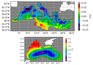
Contents: The Mean Dynamic Topography MDT-HYBRID-CNES-CLS22-CMEMS2020 contains the MDT-CNES-CLS22 for the global coverage and the MDTs CMEMS 2020 for the Black Sea (MDT-CMEMS2020-BLK) and the Mediterranean Sea (MDT-CMEMS2020-MED).
Use: ocean circulation, operational oceanography
Description: The full desciption of the methodology and of comparison to other MDTs can be found in the CMEMS QUality Information Document CMEMS-SL-QUID-008-063-066-067
Geographic coverage: global, 1/8°
Distribution media: Authenticated FTP and OpdenDap
Condition of access: The MDT-HYBRID-CNES-CLS22-CMEMS2020 is a standard product as stated in the licence agreement.
Copyright: 1992-ongoing Cnes-CLS-E.U. Copernicus Marine Service
References:
- For MDT-CNES-CLS22:
- Solène Jousset, Sandrine Mulet, Eric Greiner, et al. New Global Mean Dynamic Topography CNES-CLS-22 Combining Drifters, Hydrological Profiles and High Frequency Radar Data . ESS Open Archive . December 03, 2023. DOI: https://doi.org/10.22541/essoar.170158328.85804859/v1
- Jousset S., Mulet S., Wilkin J., Greiner E., Dibarboure G. and Picot N.: “New global Mean Dynamic Topography CNES-CLS-22 combining drifters, hydrological profiles and High Frequency radar data”, OSTST 2022, https://doi.org/10.24400/527896/a03-2022.3292.
- For MDT CMEMS 2020:
- Jousset S., Aydogdu A., Ciliberti S., Clementi E., Escudier R., Jansen E., Lima L., Menna M., Mulet S., Nigam T., Sanchez A., Tarry D. R., Pascual A., Peneva E., Poulain P.-M. and Taupier-Letage I. (2022). New Mean Dynamic Topography of the Mediterranean and Black Seas from altimetry, gravity and in-situ data. In preparation.
MDT-HYBRID-CNES-CLS22-CMEMS2020
| Product | Authenticated access service | type | format | File weight |
|---|---|---|---|---|
| MDT-HYBRID-CNES-CLS22-CMEMS2020 | access via MY AVISO+ and select the product "MDT_CNES_CLS (Global Mean Dynamic Topography)" | gridded | NetCDF4 | 48Mb |


