Synthetic method
The synthetic method is used to compute in-situ "super-observations" that are then combined with the first guess to compute MDT CNES-CLS through objective analyses. It consists in processing the in-situ data to have a physical content consistent with MDT and removing the ocean variability measured by altimetry from each in-situ observation to have an estimate of a mean.
The temperature and salinity profiles are used to compute the synthetic heights. All temperature and salinity profiles from the CORA database covering the 1993-2021 period are considered.
Geostrophic velocities from drifting buoys (1993-2021) are extracted to compute the synthetic velocities. In the Mid Atlantic Bight region, High Frequency radar data (covering the period 2006-2016) were also used to estimate synthetic velocities.
Computation of the synthetic observations of heights
For each T/S profile, dynamic height hinsitu is computed by integration of the temperature and salinity along the water column. Then mean dynamic height <h> is estimated by remonving the steric part of the sea level anomalies h'alti at the profiles's location:
<h> = hinsitu - h'alti
However, by integrating the temperature and salinity measurements along the profile, the mean dynamic height obtained is representative of the steric content until the profile's depth. To return to a synthetic estimate of the mean dynamic topography, the barotropic and baroclinic components from the profile's depth to the bottom need to be added. These missing components are approximated by subtracting to a medium-scale estimate of the mean dynamic topography (first guess), a medium-scale estimate of the mean steric component referenced to the profile's depth.
By using the first guess in the computation of synthetic heights, the useful information that we will add to the first guess in the combination is the small scales (< around 125 km) resolved by steric heights <h>.
Computation of the synthetic observations of velocities
In a similar way, geostrophic velocities extracted from surface drifter can be used together with geostrophic velocity anomalies computed from altimeter slopes. The synthetic observations of velocities are computed by subtracting, along the drifting buoys paths, the altimetric velocity anomaly to the drifters geostrophic velocity according to the equation:
<U>= Uinsitu - U'alti and <V>= Vinsitu - V'alti
In addition to the geostrophic component, the drifter velocity includes the tide currents, the Ekman currents, wind slippage, the inertial currents and others high-frequency ageostrophic currents. To extract only the geostrophic component from the drifting buoys velocities, each of these ageostrophic components should be subtracted from the buoy velocity.
The Ekman current is computed along the path and removed from the drifting buoys velocities. Note that drogued and undrogued buoys are processed in a different way. An Ekman model at 15m is subtracted from the drogued buoy velocities while undrogued buoy velocities are corrected from Ekman currents at 0m. For the undroggued buoy, wind slippage is also estimated and removed. Then a low pass filtering is applied to remove tidal, inertial and high-frequency barotropic currents, the cut-off period is the maximum between one day and the inertial period. Finally, the synthetic observations of mean geostrophic velocities are obtained after averaging in a grid box size of 1/8° by 1/8°.
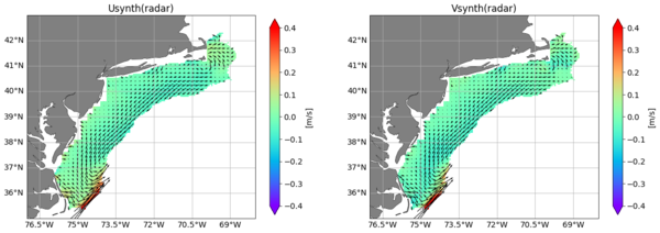
Geostrophic velocities were also extracted from High Frequency radar data, in the Mid Atlantic Bight area, East coast of the US from Cape Hatteras to Cape Cod. We used the cleaned, detited, high-frequency signal-filtered and mean currents over the period 2006-2016 (processed by Rutgers University, Roarty et al, 2020). Then the mean Ekman currents over the same period were removed and finally these mean currents were re-referenced to the 1993-2012 reference period.
Those estimates of height and velocity are finally combined in a multivariate objective analysis in order to improve the first guess.


