The direct method
The altimeter provides the sea surface height relative to the reference ellipsoid. It is the sum of the geoid plus the dynamic topography, once removed other oceanic and atmospheric effects. By averaging altimetric heights over a given period, a Mean Sea Surface (MSS) can be estimated.
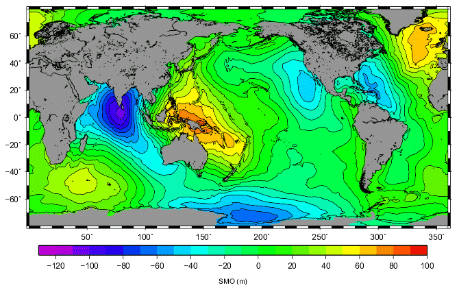
The MSS is referenced to the Earth ellipsoid; we use MSS_CNES-CLS11.
MSS is the sum of the geoid plus the mean dynamic topography MDT. Thus, by subtracting the geoid we can obtain the Mean Dynamic topography MDT; this is the so called "direct method" or geodetic MDT. We used the GOCE EGM-DIR4 geoid model.
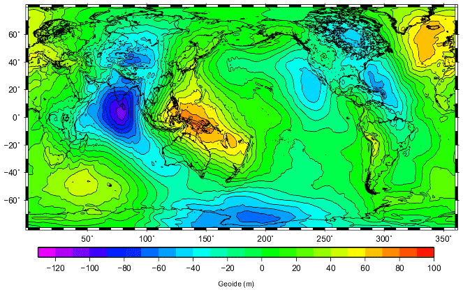
Unfortunately, satellite only geoid models do not resolve as small scales as MSS. The use of the recent GOCE data allows to resolve scales down to 100 km of resolution but it still larger than the 10 km resolution of the MSS. Thus the difference (Mean Sea Surface - Geoid) has to be filter to removed scales not accurately resolved by the geoid model. We used an optimal filter which is based on an objective analysis that takes into account the geoid omission and commission geoid errors. The resolution of this first guess is limited to the resolution for which the geoid errors are about one centimeter, thus the resolution depends on the area, it is around 125 km.
The two surfaces (Mean Sea Surface - Geoid) are subtracted, and provide after optimal filtering, a first guess of the mean dynamic topography at a large scale. The resolution of this first guess is limited to the resolution for which the errors on geoid are about one centimeter.

