Floating sargassum algae detection with Sentinel-3A&B satellites.
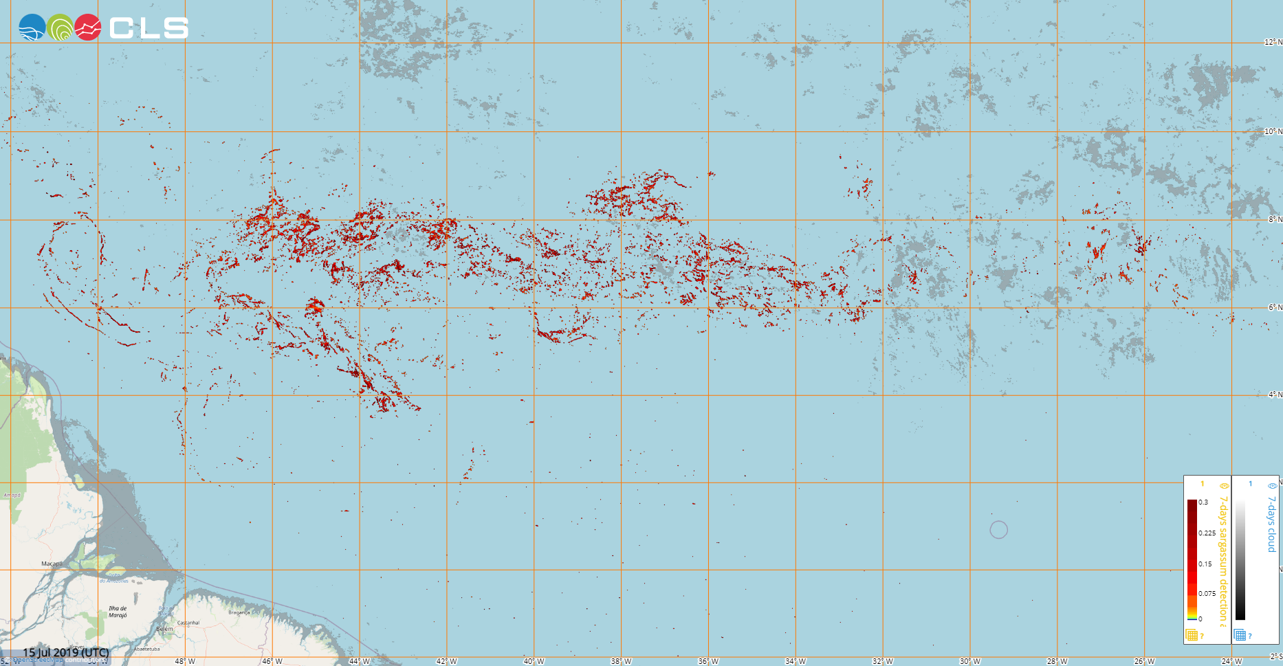
Maps of sargassum detection index NFAI (Normalized Floating Algae Index) using OLCI instruments on-board Sentinel-3A & Sentinel-3B satellites
Types of dataset: multimission dataset using OLCI ocean color sensor onboard Sentinel-3A & Sentinel-3B satellites.
DOI: 10.24400/527896/a01-2022.007 - more metadata
Contents: sargassum detection index (NFAI) maps computed from daily images of OLCI Sentinel-3A & 3B at 300m and 1km resolution since February 2022 to date. Weekly maps of 7 days averaged at 1-km are available for 2019.
Use: study the seasonal variability of the sargassum presence in the Tropical Atlantic from Gulf of Guinea to Gulf of Mexico. Identify areas affected by Sargassum events and localize sargassum rafts.
Condition of access: these products are delivered for any purposes as stated in the licence agreement
Description:
- Daily gridded products provided in near-real-time since February 2022 to amonth before current date, made available as part of SeSaM SCO project (https://www.spaceclimateobservatory.org/sesam). Each map represents the sargassum presence at 300m (high) or 1km (low) resolution.
- Weekly gridded products provided in delayed time for the year 2019 produced in the frame of the e-shape project https://e-shape.eu/ . Each map represents the sargassum presence index averaged over one week and at 1 km resolution.
Citation: when using the Floating Algae Index using Sentinel-3 satellites product, please cite
For the 2019 reanalysis data:
“The Floating sargassum algae detection product has been produced by CLS in the frame of the European project e-shape https://e-shape.eu/ , distributed by Aviso+ (DOI 10.24400/527896/a01-2022.007).”
For the datasets starting in February 2022:
“The Sargassum Floating algae detection product has been produced by CLS operationally in the frame of the SAMTool service. The product is distributed by Aviso+ (DOI 10.24400/527896/a01-2022.007) with support from SCO-CNES.”
Geographic coverage: Tropical Atlantic from -5°S to 30°N, 100°W to 15°E
Format: NetCDF-4 Classic with CF standards.
Tools:
Copyright : 2019, 2022 - ongoing, Cls
Floating Sargassum Algae detection - OLCI in Delayed-time
| Product | Satellite | DOI | Authenticated access service | Frequency | Data period | Dataset name |
|---|---|---|---|---|---|---|
| Sargassum detection - Floating Algae Index - OLCI | OLCI instruments on Sentinel-3A and Sentinel-3B | 10.24400/527896/a01-2022.007 | see your MY AVISO+ | - | From 2018/12/26 to 2019/12/31 | dataset-sargassum-merged-olci-7day-average-reanalysis-lr |
Floating Sargassum Algae detection - OLCI in Near-real-time (1 month delay)
| Product | Satellite | DOI | Authenticated access service | Frequency | Data period | Resolution | Dataset name |
|---|---|---|---|---|---|---|---|
| Sargassum detection - Floating Algae Index - OLCI | OLCI instruments on Sentinel-3A and Sentinel-3B | 10.24400/527896/a01-2022.007 | see your MY AVISO+ | daily | Feb 2022 - 1 month delay | LR (1km) | dataset-sargassum-cls-olci-s3-global-lr |
| HR (300m) | dataset-sargassum-cls-olci-s3-global-hr |

